First Seen
2015-12-18T09:30:09+00:00
simple-description (llama3.2-vision_11b)
The meme is a map of the world from the 17th century, specifically a 1673 map by the Dutch cartographer Joan Blaeu. The meme is a humorous take on the map's outdated and inaccurate representation of the world, with a caption that says "I'm not a map, I'm a map" - a play on the phrase "I'm not a doctor, I'm a doctor" - implying that the map is not a real map, but a joke about the map's outdatedness.
detailed-analysis (gemma3-27b-vision)
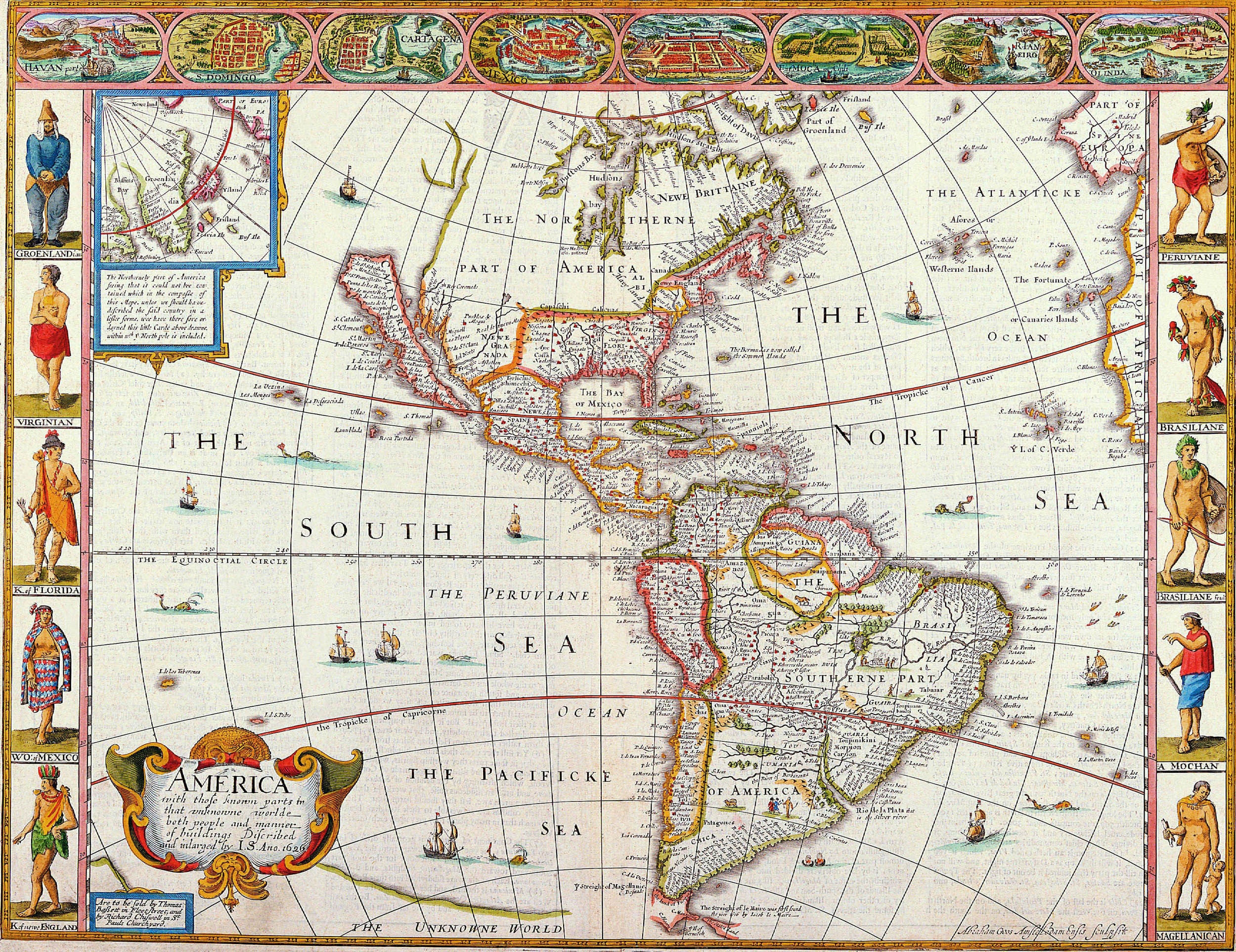
Okay, let's break down this fascinating, and loaded, 17th-century map through several critical lenses. This is a complex piece, so each section will be fairly detailed.
Visual Description
This is a hand-colored, ornately decorated map of the Americas dating likely to the mid-to-late 17th century (based on cartographic style and details). The map is dominated by landmasses representing North, Central, and South America, surrounded by the Atlantic, Pacific, and what is labeled the "South Sea". The cartography is a mixture of accurate coastline rendering and heavily embellished interior spaces.
- Cartographic Style: The map blends geographical accuracy with artistic and symbolic representation. While coastlines are relatively well-defined, inland areas are filled with illustrations of indigenous people, animals, settlements, and fantastical landscapes. The level of detail varies greatly, reflecting what was known (or imagined) at the time.
- Decorative Elements: The map is heavily adorned with vignettes, ornate cartouches, and allegorical figures. These aren’t just aesthetic; they are meant to communicate ideas about the Americas, its inhabitants, and its potential. These are heavily symbolic and clearly indicate a perspective.
- Human Figures: Indigenous people are depicted in various scenes, often engaged in daily life, hunting, or ceremonial activities. These figures are often stereotypical and contribute to the construction of the "Other". European settlers are shown building settlements and engaging in activities associated with colonization.
- Animals: Exotic animals like armadillos, alligators, and various birds populate the land, emphasizing the "newness" and “wildness” of the Americas.
- Text & Typography: The map contains extensive text in various languages, labeling geographical features, settlements, and regions. The typography is decorative and adds to the overall aesthetic.
- Insets/Cartouches: The map incorporates multiple cartouches with detailed imagery and text, often focusing on specific regions or providing contextual information. The most prominent is a large, ornate cartouche at the bottom depicting America as a semi-nude Indigenous woman.
Foucauldian Genealogical Discourse Analysis
This map is a powerful example of how power operates through discourse. Focusing on a Foucauldian lens, we can dissect how the map constructs the Americas, rather than simply representing it.
- Discursive Formations: The map embodies a discursive formation surrounding the "New World." It’s not a neutral depiction, but a product of a specific historical moment and set of beliefs. This formation includes ideas about:
- Territoriality: The map establishes a European claim to the Americas by naming, mapping, and partitioning the land. It's an act of territorialization.
- Knowledge/Power: The map represents an assertion of European knowledge over the Americas, framed by its power to name, categorize, and define. This 'knowledge' justifies colonial practices.
- The "Other": The depictions of indigenous people are constructed through a European gaze, portraying them as exotic, primitive, and potentially dangerous. This is a clear instance of "othering" – creating a category to maintain power.
- Archaeology of Knowledge: Tracing the history of how these ideas emerged, we see the map drawing on discourses of exploration, conquest, religious conversion, and mercantilism. The map isn’t a spontaneous creation; it’s built on centuries of pre-existing thought.
- Power/Knowledge: The map isn't just about the Americas; it creates the Americas as a knowable, controllable, and exploitable space. The map becomes a tool of colonial power.
- Disciplinary power: The map functions to make the Americas a legible, quantifiable space, subjecting it to European classification.
Critical Theory
Applying Critical Theory (influenced by thinkers like Adorno and Horkheimer), we can see how this map is implicated in the processes of Enlightenment rationality and its darker side.
- The Dialectic of Enlightenment: The map embodies the Enlightenment's ambition to achieve objective knowledge through reason and observation. However, this ambition is inseparable from a drive to dominate and control nature and other cultures. The map isn't a product of innocent curiosity; it’s a tool of power that facilitates exploitation.
- Instrumental Reason: The map prioritizes practical utility (navigation, resource extraction, colonization) over ethical considerations. The indigenous population and environment are treated as instruments to achieve European goals.
- Myth and Domination: The map’s embellishments and symbolic representations contribute to a mythology of the Americas as a land of abundance and opportunity for Europeans. This mythology justifies the displacement and subjugation of indigenous people. The depiction of the semi-nude indigenous woman reinforces this mythology.
- Reification: The map treats the Americas as a thing to be mapped, measured, and owned, stripping it of its intrinsic value and complexity. The land becomes a commodity.
Marxist Conflict Theory
From a Marxist perspective, this map is a manifestation of class struggle and imperial expansion.
- Material Conditions: The map is deeply embedded in the material conditions of 17th-century Europe – the rise of mercantilism, the competition between European powers, and the demand for resources and labor.
- Base and Superstructure: The map can be seen as part of the “superstructure” – the cultural and ideological institutions that reinforce the economic “base” of colonialism. It serves to legitimize the exploitation of resources and labor in the Americas.
- Class Conflict: The map reveals a clear power imbalance between European colonizers and indigenous populations. The Europeans are presented as the active agents of history, while indigenous people are often portrayed as passive or even absent.
- Imperialism and Exploitation: The map highlights the expansion of European empires and the desire to control resources and trade routes. It is a visual representation of imperial ambition and the resulting exploitation of the Americas.
- Accumulation of Capital: The map represents a key step in the accumulation of capital by European powers. The extraction of resources from the Americas fueled economic growth in Europe.
Postmodernism
A Postmodern reading would deconstruct the map’s claims to objective truth and highlight its constructed nature.
- Grand Narratives: The map embodies a “grand narrative” of European progress and dominance. Postmodernism challenges these narratives, arguing that they are based on selective and biased interpretations of history.
- Deconstruction: The map can be “deconstructed” to reveal its internal contradictions and biases. The map’s representations of indigenous people are not objective truths but rather constructions created by European colonizers.
- Relativism: Postmodernism emphasizes the relativity of knowledge. There is no single, objective truth about the Americas; there are multiple perspectives and interpretations.
- Simulacra and Simulation: The map’s embellishments and symbolic representations create a “simulacrum” of the Americas – a copy without an original. The map’s representation of the Americas is more about European fantasies and desires than about the actual landscape.
- The Death of the Author: The map is not a product of a single, authoritative voice; it is a composite of various sources and interpretations. The "author" of the map is less important than the social and cultural context in which it was created.
Queer Feminist Intersectional Analysis
This is the most challenging lens to apply directly, given the historical context. However, we can analyze the map through this framework by identifying how gender, sexuality, and colonialism intersect to create systems of oppression.
- Colonial Gendered Violence: The depiction of the semi-nude indigenous woman functions as a visual representation of colonial domination and the sexualization/objectification of indigenous bodies. This reinforces patriarchal systems of control and reinforces a narrative of European "civilization" over the "savagery" of indigenous cultures.
- Absenting Indigenous Women: The map largely marginalizes or renders invisible the roles and experiences of indigenous women. Their contributions to society are ignored or minimized. This erasure is a common tactic in colonial narratives.
- Colonial Masculinity: The map reinforces a model of European masculinity associated with exploration, conquest, and domination. This masculinity is constructed in opposition to a feminized and “savage” Other.
- Intersectional Oppression: The map demonstrates how colonialism intersected with existing systems of oppression based on gender, race, and class. Indigenous women were subject to multiple forms of discrimination and violence.
- Queering the Narrative: One could ‘queer’ the map by re-interpreting the landscape as a site of non-normative desires and identities. This involves imagining the possibilities of resistance and subversion that were not explicitly represented in the map’s conventional narrative.
In conclusion, this 17th-century map is a rich and complex artifact that can be analyzed through various critical lenses. Each perspective offers a unique insight into the ways in which power, knowledge, and ideology shaped the European encounter with the Americas.
simple-description (llama3.2-vision)
This meme is a humorous illustration of the world map from a 17th-century atlas, with the continents and oceans labeled in a decorative, old-fashioned style. The text "The World in 4 Months" appears in the top left corner, suggesting that the map is a satirical commentary on the world's current state. The meme is likely poking fun at the idea that the world is still in a state of chaos, with many countries struggling to cope with the COVID-19 pandemic.
tesseract-ocr
(oo EEE eS H = a re sa —— H SES Re ee Fae —___ i i — /pxctee emer NW, —— | ods hl pes S coy ——— Re BNAI\\\S [A Ss =DOMIN et By "E@ é <= i KS ee Gee =F PN | Se | Wel: ERE ws Wa A ic ql xk ead = eS, G NN = =e SSS Se Soe ] pt | | Nes Es WA / ae eee SY EEE HW ‘ N \ Sa Pep AL) eee 35.3% fai NA\ (aes Se H 3 if fc x e a Aw Se = Sw q ae H eed = ep ly ae eS Pe ise, Bm \ te \ pet a Se VANE i hentes SW es a | Pn yee, A aay. 18 ce Mi et es “VA es i eee aN Bl i ig [onan =< A ANDi. Bion er Cf ay day we J Gee tt sy | — = | a ree oe. phos % I = Va ) be Hee ew ~ oe >= Sey, he es (Sa) Ne fais ae iy ‘of “ \ nae eo =z San ENG Waa aan Ss as 4 iy H tad bh % re of E d e 25 kg he ges = aay \ Ca ‘i Sef SB a j At poor A | z care : Ei Roce yy Seo W4Ee i} A ee i i fe f refi a jie Se a be! a oo ie a Pe ag ae Wi H NIAN i — sa ee Ye aaee “NEW eae eS nd Bae Lg Bz peel Se N Tt} SCI pia a. @ F T BR ‘aa le ES s ‘3 yl =) i se = a 4 a = eee ‘ $k OF beled 7. LER sree Pee Ww oe, y/ bs ee Sey H ; H tates fe pes Uy 9 pa eo ce byt tone BASS c= 7 es HN H ¥ H =e = tiene 2g eG igual see * ro A Bz ont pean Se * ic Zz ye. ae BD uh 4 x Io) ms ma Ged bet 2 aaTlayte peal tt | eval == oar eA a Ba ong we aoe va Lt “ iA Pant omnes = i Weds yA Be fa ns Oe heeds See tt ee as eee oop ie y 4 eel =e, A x Oe, it Se. TS EE esl — at x sear ? a Ao Zeya a ee lA 4 i i 4 + =§ Sie Acsox stl te ted aft ee De ee ” ae i ee) (2 Ea W a % eo Da HTM Lanes oa ’ et a4 is ee? cae 2 Dist | yf A i i sh b= Saf, see £ = m he es ea ie te Paes yp ag At 4 ge || P fe ; Ff = athe AN e a, ky 2 veri aN BON. ee : F x se | J He +a | Py je le ss eae eS pete LAR ee 3 oat |# Len ze NZ Al ; eS oP cS E ier ae Bt a gas ee fee Kd 4 I igs = = a Parts At a oo as ae gone as Be a hod ak \ H i ——— BES ld - au oe leet ee Bie 2 cs t Hl fl Leese Ge ae a ie of: me ae es pee el cs ds i —= oe L ra yy ee 3 ae = . a ee iy H @ x Hl SCE ae HE a ee = fet 3 cence ag gf i i 2 | Soe ic ee ig bai ns fe Sata Ke Sa The F ac i i | | i PN Mi Ss ce [ee U ( ae zen ae =e rtun * | or ! ee My ie aa T ee. . ogee = : oe | s Ha aoe | ll sts == H Se a rs, ‘ate a, CS aeeis| | ied I H eae a oP oy ips a oe a ae oe 7 | = | i ies Al tl — Z Ava pile coat eX sgt clans © S Heo 7 ——— : di = Set see. cc N | - oe & I iL ae ae aaa oe oe N 2 i * Del iin (| 1 : HE fas eon ee uy pe 4 tl Adel = = AS eae ears) yt ee arte H ee H 4 f = eh i 1 E St ee Ge Vey oe wa : fe | 2a (i H a ol A et R Sel as sal aad & sd Whee she BURG er os” ‘hin Re A ee Ls aN H i f | a U 5 ae te Lael SV ge oe ats 235 i § q\K a i_€ Beree 8 ce fs be SE der J Aepe 2 lf i |i ee ae TAN yee se eee ees See i Sips, ee: “Gi i H ae a me oe - fn a ibe ae oe : me ed a\ah al | fg Fi } Ne ©) ie | es & = ba eed ee hs oe, a na 2 fl 5 7 i A Ke hee ES Se S i nine weer” eo ese no seat ter rhe Je K () \ a SS (SB eS —s teat a rod < Am see RRR ie ee 3 a eee Pb i H 1 Ly | = a a Je 5 =. E kes oa 5 ge os S Guia Paes oe Wer eens tr _ aes | iH tr 4 4 LS é we Bi = -| A ties Pie Le” i alge cna casi bs de areal eri pra | mt i ie a wie” aC aoe eee eek a se vo Eo —— H en ma | J I oe oe a ERI @ Cr. ae ae \ seth 2 a9 | gee SILTAN =| IH es ‘ | i WS lat a Cc ‘ Cy risen is Ae al H Peet es t - S W i ANE} fi leg bal a S oh ie an ~~ /) = y “ae Sorts) aw a She E. | cae C L ‘i a | ie LN ‘ee SICA 7 = ao So ae :¥ ae, E | y | A) ’ ro X hire! le HSS: 4, = : cae ey ez jane BORO. a. LU G4 Nee \ . dad. wala is apd. pape 4 0 A oN es D ae TNE Soo oe Fr ,* y : aA l= | \ te 1464 gs 7 de_ ZZ a elas B \ i nr A 8 sas oye rae == MPD i ale aes ees § ji ye: de iii. Ke | 7 ey | == ; HN Nie ed op TE a Peer ae t bce ae ities —— H = > iH EXG: Bebe: TEE —, BN no. Z j aes ee eee Phan fees — HT \& mm | tes Mine He is 6254 y | fete aha Sa econ a aoe ee a SS } ay 5 d Oise e A 2S a y/ enact i Sines x5 ee awl AT typ Ue ete ee Sas li WW mH = IE MK <j — I os er See eran» Oo neue) Sie Behe = is i == es Dd ee ee & pS Wenn Le a oe ~ == asp eae eee f 9 ae we (aa ase By : he ‘i ce a Gas coe Z Be pa is 4 poe i i 2 =. EA ig pee ee Lot ess ee ee Fale oe be } TASILTANE, } =a uN =\ eae eee a {2 gta piece Beekieh a a H NE fai | mee is ; ‘ pea ae a ops sae Sree ae HW : 4 ae AS item Aes t MET flo, ee ee ee A fel” H — ol ee si A 38 RI ug f MES ae cons Eo bart Li . ( = = lay = oo os ted “rege 5 lhe = HS as : wai oy aoe pare =| A aN bee 1 oo Taft ai Al eg H Se Ss ce = 7 Prim | shoe a law ay, aie ie — i safer La —| ’ fi Se eo Efe] i Sh ie i ee Ts [pie : =~ ee H V | Ss ee et ie pee “ties pone wee” "2 ty} i if AB eae Yes Se se} pal FS rate eed i tf ly a i See Zz t Sip pea 1 qi H Rete ro Pe yi a es ss ae eae fee Be] : ~ eet SS R Sh i i EES, Ni ish a ale fie Mf / BELEETA, casa = Nee